

Wyoming Phosphoria Formation Data Released as Part of Multistate Critical Minerals Study
Wyoming State Geological Survey
August 10, 2026
FOR IMMEDIATE RELEASE
Media Contact:
Bryce Tugwell, Publications and Outreach Manager
bryce.tugwell@wyo.gov
Wyoming State Geological Survey
Office: (307) 745-2236
www.wsgs.wyo.gov
Wyoming Phosphoria Formation Data Released as Part of Multistate Critical Minerals Study
LARAMIE, Wyo. — New stratigraphic and geochemical data from the Permian Phosphoria Formation in western Wyoming are now publicly available through the Wyoming State Geological Survey (WSGS).
The data were collected as part of the Western Phosphate Field Geochemical Reconnaissance Project, a collaboration among the geological surveys of Idaho, Wyoming, Utah, and Montana. The project evaluated critical mineral occurrences within the Permian Phosphoria Formation, particularly in the phosphate-rich Meade Peak and Retort members.
The project was funded through the U.S. Geological Survey’s Earth Mapping Resources Initiative, or Earth MRI, under award no. G22AC00609 to the Idaho Geological Survey, which served as the lead agency. The WSGS and the geological surveys of Utah and Montana participated as supporting agencies.
The Western Phosphate Field encompasses portions of all four states where phosphate-bearing members of the Phosphoria Formation occur. In Wyoming, the field extends across much of the western half of the state, corresponding to the known distribution of phosphatic beds within the Meade Peak and Retort members.
The Phosphoria Formation is currently mined for phosphate in Idaho and Utah. In western Wyoming, phosphate was historically mined at four locations. The state’s last active phosphate mine, the Leefe Mine, ceased production in 1977.
“The Phosphoria Formation has long been recognized for its phosphate resources, but these rocks can also contain elevated concentrations of rare earth elements and vanadium, both of which are increasingly important to the nation’s economy,” said Kelsey Kehoe, minerals geologist at the WSGS. “This work provides consistent, detailed information that can help researchers better understand where those elements occur and which rock types are associated with them.”
For the Wyoming portion of the project, WSGS geologists measured six stratigraphic sections of the Phosphoria Formation across western Wyoming. They described and sampled individual beds within each section, and the samples were analyzed for a comprehensive suite of major and trace elements.
The newly released WSGS dataset contains measured-section information, lithologic descriptions, sample data, and laboratory analytical results from the six Wyoming sites.
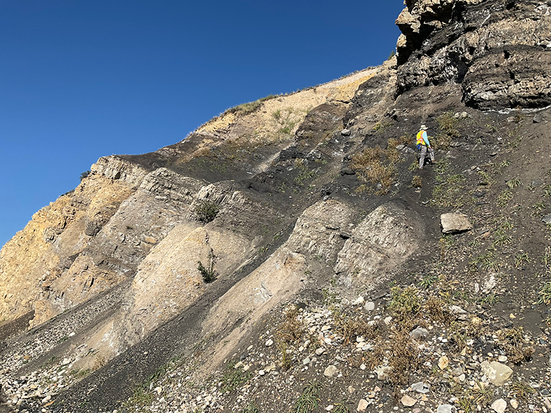
A geologist stands on dark gray rocks of the Meade Peak Member of the Phosphoria Formation. This photo was taken at the Hoback roadcut along Highway 89, which exposes beds of the Wells, Phosphoria, and Park City formations.
The field workbook and measured-section data structure used for the release were adapted from a schema developed by the Idaho Geological Survey for the multistate project. The shared structure allows researchers to compare stratigraphic and geochemical information consistently across the Western Phosphate Field.
“These data preserve the detailed observations collected at each Wyoming site and make the analytical results available for future research,” said Ranie Lynds, interim WSGS director and state geologist. “They provide a foundation for evaluating regional geochemical patterns and identifying questions that may warrant more focused study.”
The Wyoming dataset complements a new Idaho Geological Survey technical report, Geochemical Characterization of the Western Phosphate Field, Idaho, Montana, Utah, and Wyoming. The report includes chapters describing the measured sections and geochemical results from each participating state, as well as an analysis of broader geochemical patterns across the study area.
The report focuses on critical minerals, including rare earth elements, and examines the rock types and stratigraphic intervals with which those elements are most closely associated. It also includes detailed logs for each measured section showing the stratigraphy and variations in major elements and selected trace elements of critical mineral interest.
The WSGS data release is available to download here. The Idaho Geological Survey technical report and accompanying regional data are available at https://www.idahogeology.org/product/T-26-02.
Earth MRI is a partnership between the U.S. Geological Survey and state geological surveys that works to improve knowledge of the nation’s geologic framework and critical mineral resources. The program supports geologic mapping, geophysical surveys, geochemical investigations, and other research intended to reduce uncertainty about the occurrence of minerals important to the nation’s economy and security.
Legal Disclaimer:
EIN Presswire provides this news content "as is" without warranty of any kind. We do not accept any responsibility or liability for the accuracy, content, images, videos, licenses, completeness, legality, or reliability of the information contained in this article. If you have any complaints or copyright issues related to this article, kindly contact the author above.
